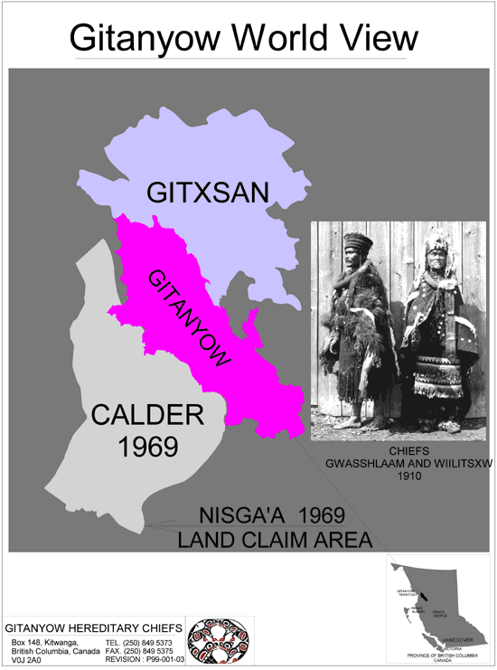
Land Claim
The Gitanyow Houses and Chiefs hold and exercise aboriginal rights and title on approximately 6,500 square miles of traditional territory in the mid-Nass watershed.
In 1994 the Gitanyow comprehensive claim to these territories in the mid-Nass watershed was accepted for negotiation by both the federal and provincial governments.
Gitanyow Agreement Area
Map of Gitanyow House Territories
(inset map)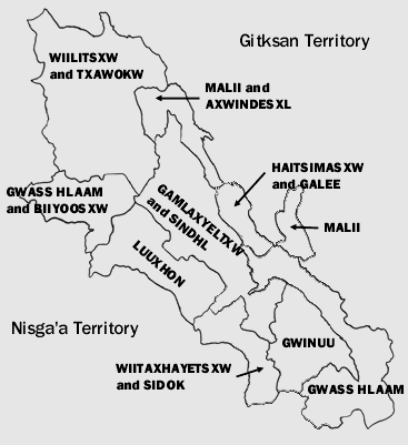
Gitanyow House Territories
The Gitanyow Nation have their own system of territorial ownership. This system includes processes to establish ownership, to transfer territorial ownership and to resolve conflicts over boundaries. The Gitanyow have consistently demonstrated ownership of their traditional territories with respect to both their First Nation neighbors and European settlement.
The Gitanyow Territory is divided into House Territories, each of which is owned and managed by the respective Chiefs. Below is a chart and a map showing the territories by each House Group.
The Eight (House) Chiefs and Their Territories
| ||
| CLAN | HOUSE | TERRITORIAL REGION |
|---|---|---|
| LAX GIBUU | Gwaas Hlamm | 9 Mile; Gitanyow Village; Upper Cranberry |
| Malii | Sweeten River; Brown Bear & Kwinageese River | |
| Haits'imsxw | Swan Lake | |
| Wiilitsxw | Meziadin Lake | |
| LAX GANADA | GamLaxyeltw | 9 North of Cranberry River & West Nass area |
| LuuHon | Kinskuch River Watershed | |
| Gwinuu | Upper Cranberry River and 26 Mile area | |
| Watakhayetsxw | Eastern Kiteen River |